HO CHI MINH CITY APPLIES UAVS TO IMPROVE MANAGEMENT EFFICIENCY AND DIGITIZE LOCAL DATA
Ho Chi Minh City is deploying UAVs to survey, map, and digitize current-state data across 168 wards, communes, and special zones. Starting with Tru Van Tho Commune, CT UAV and GASCO are collaborating to collect spatial data, contributing to local management, digital government development, and the growth of the low-altitude economy.
The project “Application of UAVs for Data Digitization across 168 Wards, Communes, and Special Zones,” implemented by the Ho Chi Minh City Department of Science and Technology, marks an important step in bringing high technology into practical management. Within the framework of the project, on June 26, 2026, CT UAV and GASCO conducted a UAV-based digital mapping flight in Tru Van Tho Commune to record the area’s current conditions, collect aerial imagery, and build spatial information layers to support local management.
With its suburban characteristics, including residential areas, agricultural land, transportation infrastructure, canals, and scattered geographical features, the area is suitable for evaluating the feasibility of UAV-based spatial data collection under real-world conditions. The data obtained will serve as an initial foundation for building a visual, synchronized, and updatable information source to support local management.

UAV digital mapping flight over Tru Van Tho Commune. Photo: CT UAV
An additional management tool for grassroots authorities
Compared with manual surveying methods, UAVs can quickly cover large areas and access scattered locations or areas that are difficult to observe directly. Aerial imagery helps capture relatively comprehensive information on current land use, structures, transportation infrastructure, water bodies, and spatial changes over time.
After being processed and standardized, the data can be used to build digital maps, monitor geographical changes, and support management agencies in verifying and cross-referencing information. It also provides a basis for fields such as planning, construction, transportation, natural resources, environment, and socio-economic development.
For local governments, visual data can help reduce reliance on fragmented reports while improving the ability to detect changes on the ground. For example, digital maps can support the monitoring of land-use changes, updates to transportation networks and canals, the identification of infrastructure areas requiring inspection, and planning activities.
When integrated into digital platforms, each data set can be organized into separate information layers, allowing authorities to utilize the data according to specific needs. Regular updates also make it possible to compare current conditions across different time periods, thereby providing an additional basis for decision-making.
Mastering technology to support digitalization
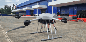
In the project, CT UAV is responsible for flight equipment and technology, while GASCO handles the organization and operation of services related to the low-altitude economy. The UAV is developed on the CT–Nexus Flight Control System platform, which enables stable operation across various terrain conditions.

CT UAV engineers inspect the equipment before operation. Photo: CT UAV
The deployed UAV weighs 3.5 kg, has a maximum payload of 5 kg, and can fly for up to 60 minutes under no-load conditions. It reaches a flight speed of 10–15 m/s, has a maximum control range of 15 km in unobstructed conditions, and can withstand Beaufort scale 6 winds. The UAV is equipped with a 4K HD camera supporting 6x hybrid zoom for aerial imagery collection. A key difference of the UAV’s camera is that, when combined with mapping data collected by the UAV, the system can provide high-resolution field imagery with five times more detail than satellite imagery. This creates a high-quality input source for digitizing current-state data, building digital maps, and forming spatial data layers.
According to the implementing unit, the device has a localization rate of 87.5%, demonstrating the design, manufacturing, and technology integration capabilities of Vietnamese engineers. The captured image data has high resolution, meeting the requirements for building digital maps and forming spatial data layers for management purposes.
Data from aerial survey operations can also be used as input for the 15-layer National Digital Twin – NDT15 technology within the CT Group ecosystem. Bringing real-world conditions into a digital environment helps support the simulation, analysis, and comparison of spatial information.
Starting from the deployment point in Tru Van Tho Commune, the project lays the foundation for expanding UAV applications across 168 wards, communes, and special zones of Ho Chi Minh City. Once the data is standardized, updated, and connected to existing management systems, UAVs will not only serve as recording devices but can also become tools to support local governance, contributing to digital government development and improving the efficiency of urban and rural management.
Source: Trung tâm thông tin và thống kê KH&CN
________________________